

Key Takeaways
- Much of New Orleans sits at or below sea level, making flood management a constant civic priority.
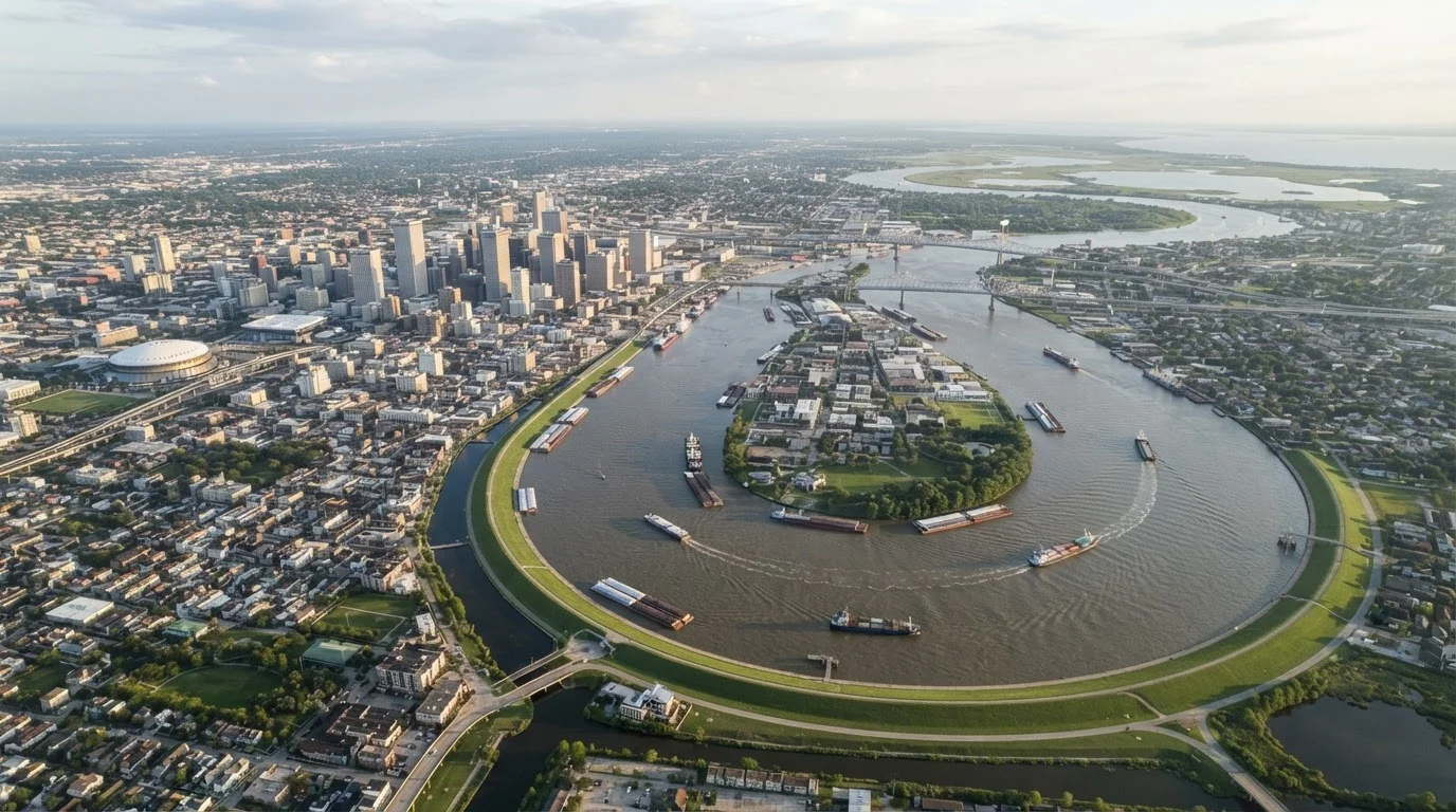
- The city's curved street grid follows the natural bend of the Mississippi River, not a standard north-south compass orientation.
- Older, higher-elevation neighborhoods like the French Quarter face lower flood risk than newer lower-lying areas.
- Raised houses, wide gutters, and cistern architecture reflect centuries of adapting to a wet environment.
- The city's geography directly shaped its cultural mix, trade history, and neighborhood identities.
River Delta Urban Geography
River delta urban geography refers to how cities built on river deltas are shaped by their natural environment - including elevation, soil composition, flood patterns, and waterway placement. New Orleans is one of the world's most striking examples: a major city constructed on a low-lying delta where land, water, and human engineering are in constant negotiation. Understanding this helps visitors make sense of everything from the street grid to the raised architecture they see on arrival.
The Mississippi River Delta is an accretionary landform built from sediment deposits over thousands of years. As the river's flow slows near the Gulf of Mexico, it drops suspended sediment, gradually building land - but also making that land highly compressible and prone to subsidence.
A City Shaped by Its River
New Orleans was founded in 1718 on a narrow strip of relatively high ground between the Mississippi River and Lake Pontchartrain - one of the few places in the delta where settlement was even marginally practical. That original settlement, now the French Quarter, sits on a natural levee: a ridge of compacted sediment deposited by centuries of river flooding. This elevated spine became the backbone of early development and still influences which parts of the city feel most stable today.
The Mississippi doesn't run straight through the region - it curves dramatically, and early city planners laid out streets to follow that curve. The result is a street grid that bends with the river rather than aligning with true north or south. Locals navigate by river-relative directions: riverside (toward the Mississippi), lakeside (toward Lake Pontchartrain), uptown (upriver), and downtown (downriver). First-time visitors who rely on compass directions often find themselves disoriented within minutes of arrival.
~50%
Percentage of New Orleans below sea level
U.S. Geological Survey data indicates roughly half the city's land area sits at or below sea level, with some sections 6 feet or more below the Gulf of Mexico.
350 miles
Mississippi River length above New Orleans
The river drains approximately 1.2 million square miles of North American interior before passing through New Orleans, making the city's trade position historically immense.
120+
Pumping stations in the city drainage system
New Orleans operates one of the largest urban drainage pump systems in the world to manage rainfall and prevent street-level flooding during storms.
Elevation, Subsidence, and What Lies Beneath
As New Orleans grew through the 19th and 20th centuries, developers drained the cypress swamps and marshes that lay between the river ridge and the lakefront. Powerful pumping systems removed standing water, converting wetland into buildable land. The problem: once drained, organic soils lose their buoyancy, compact under the weight of buildings, and slowly sink - a process called subsidence. The result is that many neighborhoods built on reclaimed swamp now sit several feet below sea level.
This creates a counterintuitive geography where the oldest neighborhoods are the highest, and some of the newest residential areas carry the greatest flood exposure. During Hurricane Katrina in 2005, the pattern was stark: neighborhoods near the river ridge stayed mostly dry, while lower-lying areas experienced catastrophic flooding when levees failed. Understanding this elevation gradient helps travelers appreciate why locals are so attentive to which neighborhood they're in - and why real estate values often track with a few feet of elevation.
How Geography Shaped Architecture and Culture
The environment didn't just shape the land - it shaped the buildings, the street life, and the cultural character of New Orleans in ways visitors notice immediately. Homes throughout the city are typically raised on piers, brick pillars, or concrete blocks to allow floodwater to pass beneath. Wide, overhanging galleries (porches) shade walls and windows from intense subtropical sun while channeling rain away from foundations. Wrought-iron railings, internal courtyards, and thick plaster walls all reflect centuries of practical adaptation to heat, humidity, and the ever-present threat of water.
The city's geography also made it a commercial crossroads. Sitting at the mouth of the Mississippi, New Orleans was the natural gateway for goods moving between the American interior and global markets. That position drew French, Spanish, African, Creole, and Anglo-American communities into close proximity, producing a cultural blend - in food, music, architecture, and religious practice - that remains unlike anywhere else in the United States.
Use Neighborhood Elevation Maps Before You Book
Publicly available flood maps and elevation data for New Orleans neighborhoods can help you choose accommodations with lower flood risk, especially if you're visiting during summer storm season. The city's Office of Resilience and Sustainability publishes resources online. Knowing your neighborhood's elevation won't ruin the trip - it will help you plan it more realistically.
What Visitors Should Know Before They Arrive
Understanding New Orleans geography makes you a more informed traveler. When choosing accommodations, look into neighborhood elevation - resources like the city's flood maps and local news organizations provide this information publicly. The French Quarter, Marigny, and Garden District are popular partly because they sit on higher ground. Areas closer to the lakefront or in lower-lying districts may be perfectly safe during a typical visit but carry different risk profiles during heavy rain events.
Rainfall in New Orleans can be intense and sudden, particularly in summer. The city's drainage system, while extensive, can be overwhelmed during major storms, leading to street flooding even in the absence of a hurricane. Comfortable waterproof footwear is genuinely practical rather than just cautious advice. Finally, recognize that the city's geography is not a liability to be ignored but a defining feature to understand - it is precisely what made New Orleans the city it became.